

Ultimate Guide to Hiking Kristínartindar in Iceland
- GoAndXplore
- No Comments
Ultimate Guide to Hiking Kristínartindar in Iceland
- GoAndXplore
- No Comments
Facebook
Pinterest
LinkedIn
Twitter
Ola and I have visited Kristínartindar three times, and we will be for sure visiting again.
With an impressive elevation of 1,126 meters (3,694 feet), it’s one of the most stunning mountain peaks we have explored in Iceland so far.
We thoroughly enjoyed the hike, and we absolutely loved the panoramic views of Vatnajökull and its outlet glaciers. If the visibility is good, you can also see Iceland’s highest peak, Hvannadalshnúkur, and its neighbor, Dyrhamar.
In case you’re planning to explore Kristínartindar, here’s everything you need to know.
TABLE OF CONTENTS
Where is Kristínartindar Located?
Kristínartindar is located within the Skaftafell Nature Reserve. The reserve is part of the vast Vatnajökull National Park in Southeast Iceland, and it’s accessible by the Ring Road.

Vatnajökull is home to some of Iceland’s most scenic “untouched” destinations, including Mulagljufur Canyon that we recently explored.
How to Get to Kristínartindar?
You can get to Kristínartindar in three ways. You can drive yourself, take a bus, or join a tour. Self-driving is, however, the best option. It’s because the buses only operate from some towns/ cities and the tours often include Kristínartindar as part of a broader South Coast itinerary.
Let’s have a look at all these options in detail.
How to Drive to Kristínartindar?
Kristínartindar is located in the Skaftafell Nature Reserve, which is accessible by the Ring Road (Route 1). If you’re driving from Reykjavík, the journey takes around 5-6 hours, with the distance of 323 km (200 miles).
Here’s the location on Google Maps
On your way, you will pass through a number of towns. These include Hverageroi, Selfoss, Hella, Hvolsvollur, and finally Vik.
Vik is the nearest major town to Skaftafell, located 141 km away. Other nearby towns include Höfn, 130 km to the east, and Kirkjubæjarklaustur, 69 km to the west.
Before you enter Vik, you get to see a couple of picturesque waterfalls. And after leaving it, you pass through Reynisfjara black sand beach, Dyrhólaey hill island, and Ice Cave beneath the Katla Volcano.
These are just some of the attractions you’ll see along the South Coast. The entire journey is mesmerizing. So much so, you’ll want to make at least a couple of stops.

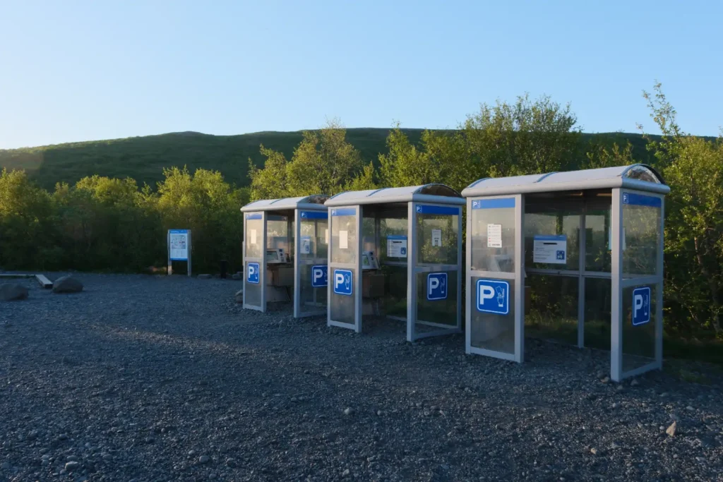
Where to Park for Kristínartindar?
You have to park your car at the Skaftafell Visitor Centre before starting your hike. You’ll have to pay a parking fee either onsite or by using the Parka app. Don’t park your car directly at the Skaftafell campsite as this parking area is designated for people staying overnight.
All day visitors need to park in the parking lot that comes at the second turn after passing the Skaftafell gates. You’ll easily recognize it by the colorful kiosks.
The parking fee is as follows:
| Vehicle Type | Parking Fee (ISK) |
|---|---|
|
Passenger Car (5 or fewer seats) |
1,040 |
|
Passenger Car (6–9 seats) |
1,350 |
|
Motorcycle |
420 |
If you visit another fee-based Vatnajökull National Park area on the same day, you’ll get a 50% discount on parking. For more details, you can visit this link.
Can You Take a Bus to Kristínartindar?
As of now, Strætó is the only bus service operating a major route to Skaftafell during the summer season, from May to September. You can take Strætó’s Bus 51 from Reykjavík. But keep in mind that the route is not direct and involves transfers.
The full journey from Reykjavík to Skaftafell by bus takes at least 9 hours.
Visit the official Strætó website for up-to-date bus schedules. You can also take a bus from nearby towns.
Are There Any Tours to Kristínartindar?
If you want a convenient and hassle-free experience, you can join a guided tour. This way, you can focus on exploring the location instead of dealing with navigation and logistics.
As of now, we couldn’t find any solo tour from Reykjavik.
Icelandic Mountain Guides offers a guided hike to Kristínartindar for $242/person, but it starts from Skaftafell Visitor Centre. Get Your Guide also offers a similar guided hike from the visitor centre for $240/person.
A number of tour operators, however, include Kristínartindar as part of a broader itinerary exploring other South Coast destinations.
Whenever you choose a tour operator, prefer those with vakinn.is certifications. This is the official quality and environmental certification system of the Icelandic Tourist Board. Businesses with Vakinn certification meet high standards for service, safety, and environmental responsibility.
What's the Best Time to Explore Kristínartindar?
The best time to explore Kristínartindar is during the summer months, from June to August. You get the longest daylight hours, including the “Midnight Sun.” This provides ample time for the challenging 6-8 hour hike.

But keep in mind that the temperatures in Skaftafell can be cold even in summer. Moreover, the wind can be really strong at times.
Ola and I visited Kristínartindar three times, and all of our trips took place in the summer months.
Skaftafell is open year round so you can visit anytime, but the hike is officially open only in summer and can be risky to undertake in winter.

Before your trip, we recommend to check weather forecasts on vedur.is, and road forecasts on road.is.
From years of experience as tour guides in Iceland, we can’t overemphasize how unpredictable and sometimes dangerous Icelandic weather can be.
If you’re new to adventuring in Iceland, you can also check our detailed weather guide.
Where to Stay Near Kristínartindar?
Skaftafell Nature Reserve is the closest accommodation for visitors exploring Kristínartindar.
You can choose to camp at the Skaftafell campsite in a tent or campervan, or you can lodge in nearby hotels and guesthouses.
Hotel Skaftafell, for instance, is a popular choice for those seeking comfort and convenience. Hotel Jokulsarlon is another luxurious lodging option. Luckily, you can also find a number of affordable guest houses near the park.
The Skaftafell campsite is open year-round. It can accommodate up to 400 tents. There’s also a designated area with electrical hookups for campers and trailers.

It’s a great campsite with plenty of space and clean, well-maintained facilities. You get all essential amenities like flush toilets, showers, a washing machine, and a dryer. You’ll also find privately operated restaurants and 3G mobile connectivity.
You need to pay a fee upfront at the reception.
| Category | Fee (ISK) | Details |
|---|---|---|
|
General Fee (17–66 years) |
2,800 per person/night |
Includes shower, washing machine & dryer access |
|
Seniors (67+ years) & Disabled |
2,300 per person/night |
Discounted rate |
|
Children (16 & under) |
Free |
Must be accompanied by an adult |
|
Long Stay Discount |
15% off |
Applies for stays of 5 consecutive nights or more |
|
Electricity |
1,500 per 24 hours |
For campers and trailers |
Please note that there are no indoor dining or cooking facilities at the Skaftafell campsite. For more details, please visit this link.
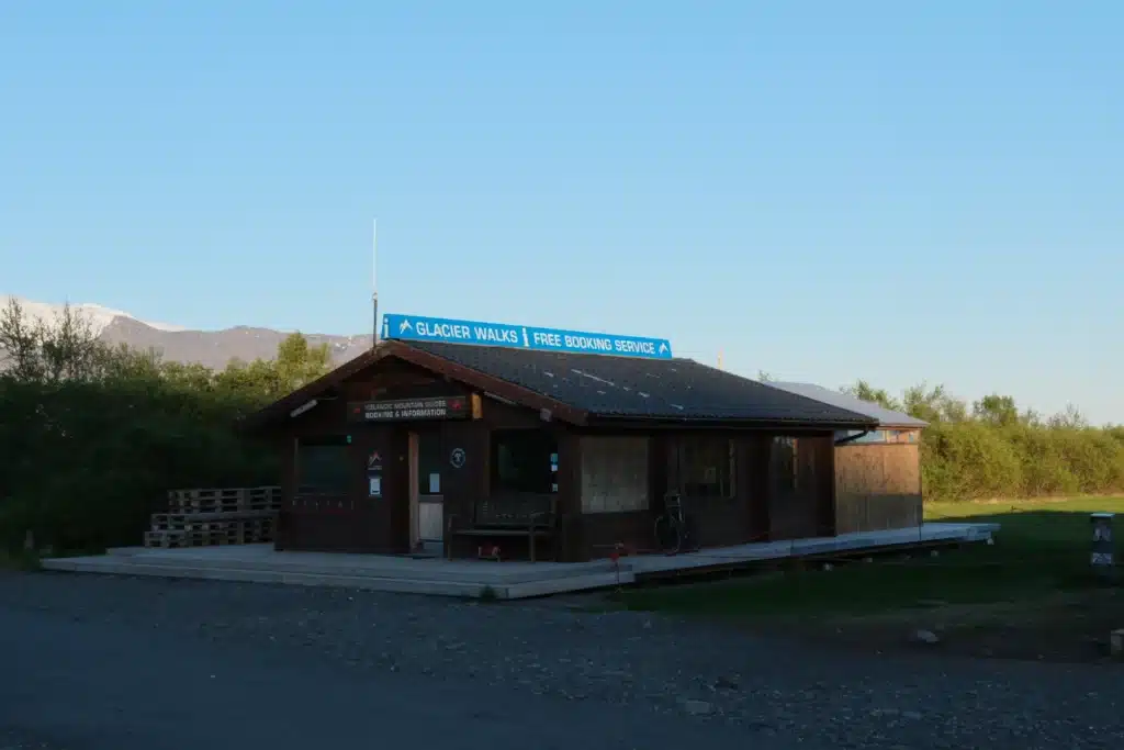
Does Kristínartindar Have a Visitor Centre?
Skaftafell Visitor Centre serves as the main gateway to people exploring Kristínartindar. It offers information, maps, and guidance for all hiking trails in the area, including routes to Svartifoss waterfall and Skaftafellsjökull glacier.
The centre also has restrooms, a café, and a souvenir shop, which makes it a ‘must’ stop for travelers.
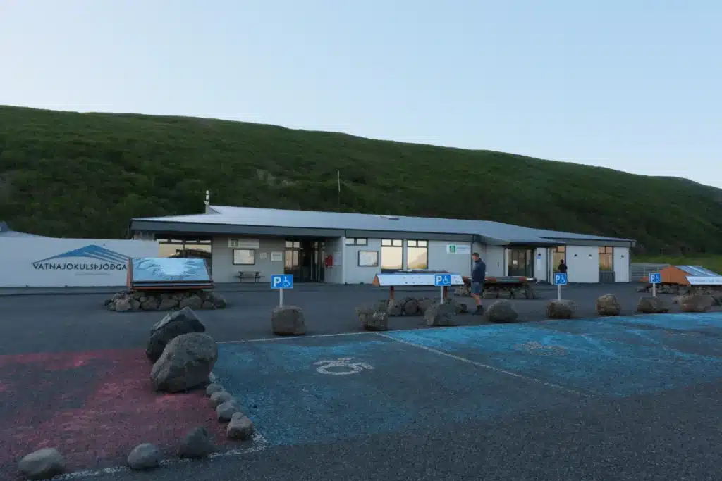
Like the campsite, it’s also open year-round. Visitors can get safety advice, weather updates, and guided tour recommendations.
The centre also serves as the base for glacier guides, as all Skaftafell tours start from this point.
Kristínartindar Hike
-
Distance:
19 km
-
Trail Type:
Loop
-
Time:
6-8 Hours
-
Difficulty:
Moderate
-
Elevation +
1119 m
The Initial Climb & Sjónarnípa Viewpoint
The hike to Kristínartindar begins at the Skaftafell Visitor Centre.
At the start, the trail is wide and very easy to follow. It winds through low bushes and can be muddy after rain. This first section is shared with other popular hikes in the area, including the route to Svartifoss.
You will then enter an open area with panoramic views. Here, you’ll see a large sundial pointing towards a number of stunning landmarks. One of these landmarks is the Sjónarnípa viewpoint.

Sjónarnípa is a rocky outcrop, widely considered the best viewing point in Skaftafell Nature Reserve. From here, you can perfectly view the vast expanse of the Skaftafellsjökull glacier, which is a tongue of the Vatnajökull.

Once you pass the sundial, the summit of Kristínartindar becomes visible. It appears deceptively close, but it isn’t.

The path continues to climb gradually, and you will have Skaftafellsjökull glacier on your right for most of the time. There is few more view points where you can stop and take amazing photo shots.

At one point, the trail almost disappears, and it’s necessary to traverse through a 5-meter-long exposed section.
Here we would recommend extra caution and crossing a few meters higher to avoid the risk of slipping and falling into the exposure.
Just look around and you will see another passage a little higher from where you stand.

After overcoming this relatively steep section, you will reach the junction of two paths. The left path is for the descent back to Skaftafell and the right is for Kristínartindar.
From this point, you can clearly see the final push to the summit. It’s a steep, rocky path with loose gravel and a few exposed spots.
The Challenging Final Ascent
Many hikers stop at the junction, and instead of pushing for the summit, they continue to descend in the direction of Skaftafell and Svartifoss waterfall.
If you decide to go further and explore the summit, it’s good to be aware of a few things.
While getting on the ridge, the last 50-meter-long section can be tricky. The trail is not marked, and hikers sometimes push towards the ridge too early. This may result in a 10-minute scramble through difficult terrain just to realize later that there is no safe way forward.
We recommend slowing down here and looking carefully for the path.

While finally on the ridge, it’s only a few minutes to reach the summit.

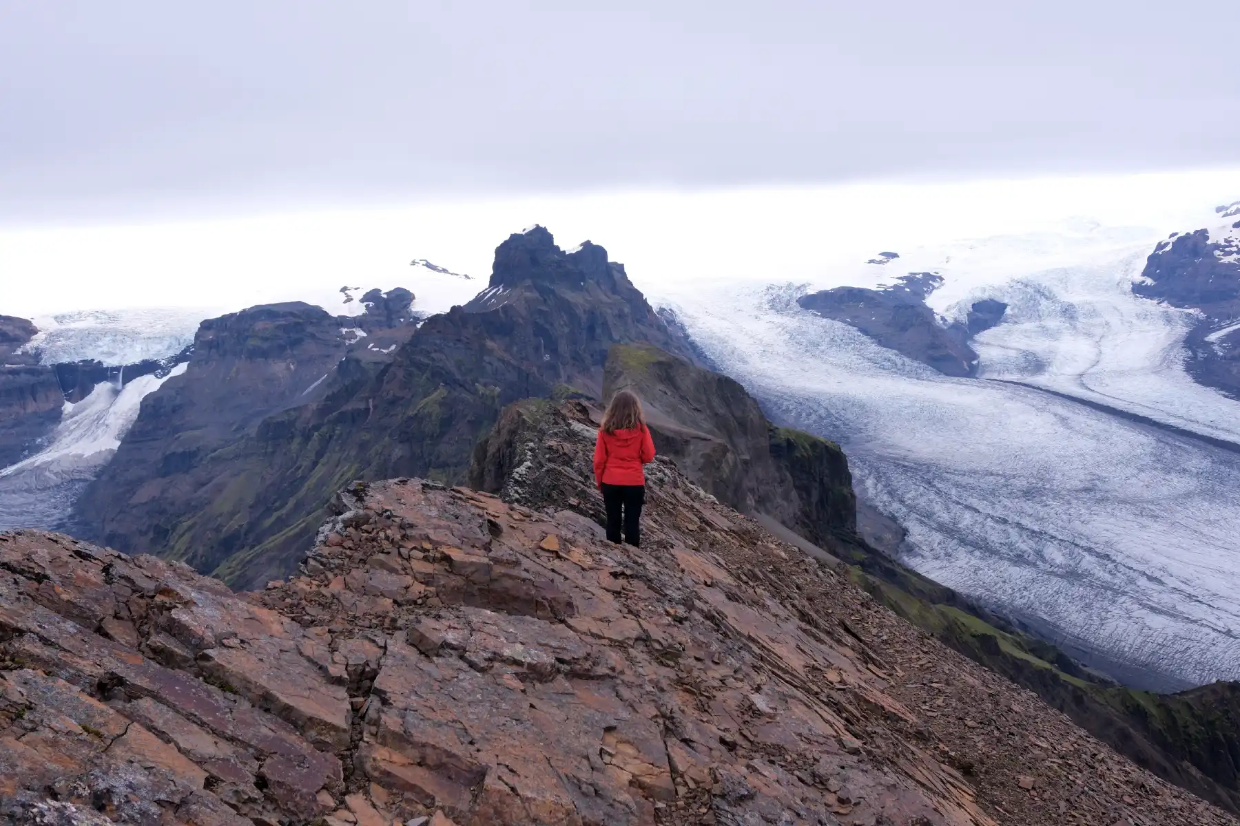
With an elevation of 1,126 meters, Kristínartindar summit is the highest point on the Skaftafellsheiði massif. Just for a little perspective, it’s two and a half times higher than Vestrahorn.
Reaching the top is a significant accomplishment, and the reward is a breathtaking panorama, making your hike worth every step.

The views from the summit are amazing… you can see a 360-degree vista of the surrounding Vatnajökull National Park including Morsárfoss waterfall. This is Iceland’s tallest waterfall at 228 meters. It’s fed by the meltwater from the Morsárjökull glacier, which is an outlet glacier of the mighty Vatnajökull.

But be careful to maintain distance from the ridge edges as falling over would have catastrophic consequences.
Winds in Iceland are unpredictable, and one unexpected gust may cost someone their life.
The summit is a very peaceful place, and is ideal for contemplation or a short meditation. In other words, don’t rush down if you don’t need to. It took some time to get here, so enjoy the reward!
The Descent & Svartifoss Waterfall
The route back to Skaftafell is pretty straightforward.>>>
Simply retrace your steps from the summit and descend to the junction. Once you’re there, you can either return directly along the same route or continue on the loop towards the Svartifoss.
If you continue to Svartifoss, the first half kilometer is rocky.

But after that, the terrain changes and transforms into a pleasant mountain path full of flowers and greenery.

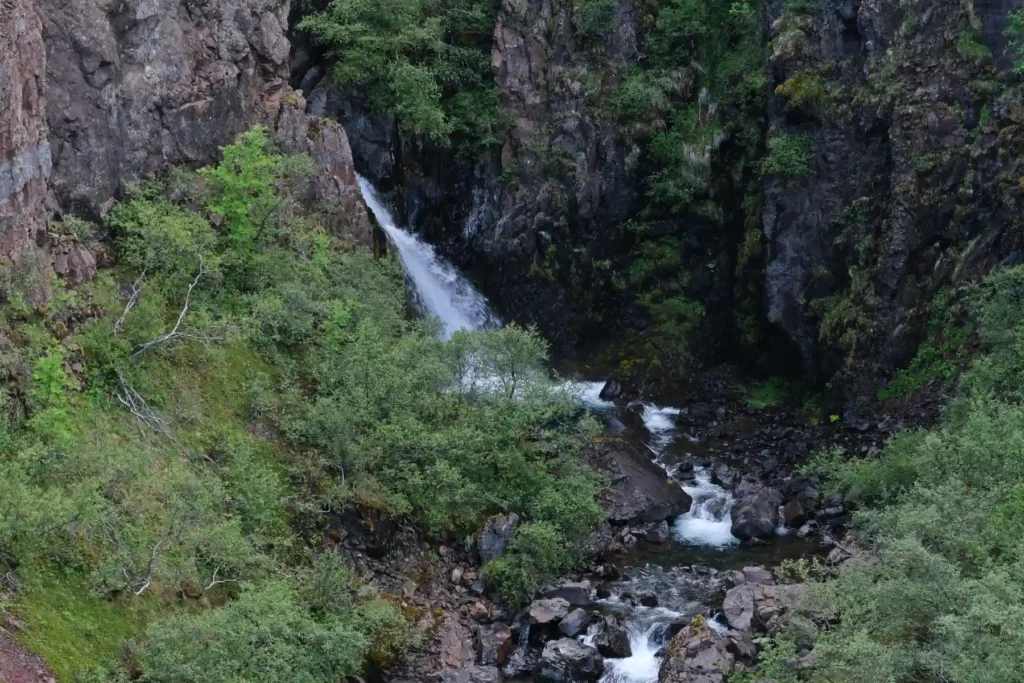
The descent from here is gradual and not difficult, but may appear a little long, though. Along the way, you’ll pass Svartifoss, Hundafoss and Magnúsarfoss waterfalls.
Hundafoss, which translates to “Dog’s Waterfall,” is a powerful waterfall that flows over a series of ledges and truly captivates you.
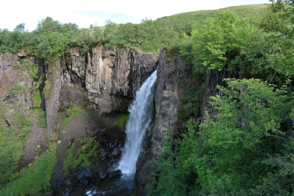
Magnúsarfoss is another stunning waterfall with a charm of its own. It cascades over a series of moss-covered rocks, creating a serene sight.
Despite being absolutely beautiful, both waterfalls are overshadowed by the more famous Svartifoss that appear as the very first waterfall as you descent.
Svartifoss is one of the most famous and unique waterfalls in Iceland. Its name, “Black Falls,” is actually a reference to its dark hexagonal shaped basalt columns that frame the cascading water and create a truly enchanting sight.

From Svartifoss, you’ll find a wide, well-trodden path leading back to the Visitor Centre and completing the loop.
All in all, we loved the hike. The only thing we missed was the chance to immerse ourselves in a hot spring after hours of hiking, like we did at Landmannalaugar and Kerlingarfjöll.
Kristínartindar Hike Map & GPX
Which Items to Pack for Kristínartindar?
Here are the essential items you need to pack:
- Layered clothes
- Study hiking boots
- Trekking poles (optional)
- Quick dry pants
- GPS/ Offline maps
- Water bottle and snacks
- Toiletries and hygiene items
- Medications and first-aid kit
- Sunglasses and sunscreen
- Camera
If you plan to stay overnight at Skaftafell campsite, you need to bring tents, utensils, and cooking gear as well.
Keep in mind that your packing list always depends on the length and nature of your stay. For instance, if you’re hiking a multi-day trail like Laugavegur, you’ll definitely be packing a lot.
Also, don’t forget weather when packing.
Working as tour guides in Iceland, we can confirm that weather here can change in minutes, and that you can pretty much experience all four seasons in a day.
So, pack for wind, rain, snow, and sun!
If you’re new to Iceland travel, our detailed packing guide might help.
Kristínartindar Travel Tips
Start your hike early to avoid late-day fatigue on the final climb.
Make sure to pack for all types of weather.
Check vedur.is for weather forecasts and road.is for road conditions. Keep checking them frequently during your trip as well.
Choose tour operators that prioritize sustainability and respect for the natural environment.
Always follow designated trails to protect both yourself and the delicate vegetation.
Act responsibly and follow the Leave No Trace principles.
Summary
Kristínartindar peak, with its sharp ridge, is the number one viewpoint in the Skaftafell area and should not be missed while traveling the South Coast of Iceland.
Driving yourself to Skaftafell is the best option to get to Kristínartindar. The journey from Reykjavík takes around 5-6 hours. Car parking is available at Skaftafell Visitor Centre and you have to pay a fee.
Summer months, from June to August, offer the best time to explore Kristínartindar. You get longer daylight hours for hiking and weather/road conditions are good.
For accommodation, you can either camp at the Skaftafell campsite or can lodge in nearby hotels and guesthouses. The campsite and visitor centre offer almost all kinds of services, and are open year-round.
Kristínartindar hike begins from the visitor centre. It’s an 19 km (12 miles) moderate trail with lots of rewards that make hiking it worth every step.
We hope we’ve covered most of your questions. If you have something more to ask, feel free to leave a comment below. 😉
Facebook
Pinterest
LinkedIn
Twitter
How do we rate this location?
FAQ
Which direction to hike the Kristínartindar trail?
We would recommend you hike the Kristínartindar loop counter-clockwise. This way, you’ll ascend the most technical section rather than descending it.
What's the difficulty level of the Kristínartindar trail?
Most of the trail is relatively easy to navigate as the path is well visible. The only challenging sections comes 0.5 km before the junction towards the summit, where hikers need to deal with loose rocks and exposure and then the steep incline towards the summit itself. Overall, it is a moderately difficult hike.
Is the Kristínartindar hike worth it?
Yes, the Kristínartindar hike is absolutely worth it. We rate it 4.5/5 for breathtaking glacier views, the magical atmosphere of the summit, and only a few hikers in the upper section of the trail.
> YOU MAY ALSO LIKE

Crystal Ice Cave Tour at Jökulsárlón – Review in 2025
20 January 2026
No Comments

Diamond Beach in Iceland: Your Ultimate Travel Guide
7 January 2026
No Comments
TABLE OF CONTENTS